Topography
|
What is topography?
Topography describes the physical features of an area of land. These features typically include natural formations such as mountains, rivers, lakes, and valleys. Manmade features such as roads, dams, and cities may also be included. Topography often records the various elevations of an area using a topographical map. Topographical Features Topography studies the elevation and location of landforms.
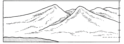
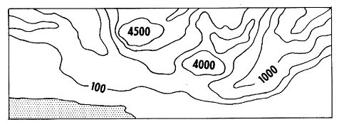
A topographical map is one that shows the physical features of the land. Besides just showing landforms such as mountains and rivers, the map also shows the elevation changes of the land. Elevation is shown using contour lines. When a contour line is drawn on a map it represents a given elevation. Every point on the map touching the line should be the same elevation. On some maps, numbers on the lines will let you know what the elevation is for that line. Contour lines next to each other will represent different elevations. The closer the contour lines are to each other, the steeper the slope of the land. The map to the right shows the contour lines for the above hills Ways Topography is Studied There are a number of ways that information is gathered to make topographical maps. They can be divided into two primary methods: direct survey and indirect survey. Direct survey - A direct survey is when a person on the ground uses surveying equipment, such as levels and clinometers, to directly measure the location and elevation of the land. You have probably seen a surveyor along the road sometime making measurements by looking through a leveling instrument sitting on a tall tripod. Indirect survey - Remote areas may be mapped using indirect methods. These methods include satellite pictures, images taken from planes, radar, and sonar (underwater). What is topography used for? Topography has a number of uses including:
http://www.ducksters.com/science/earth_science/topography.php |
|
